
Major Polar Vortex Disruption Confirmed: Arctic Blast Forecast for U.S. and Canada in Late January
Meteorologists have confirmed a major Polar Vortex disruption is currently underway, signalling a severe shift in winter weather patterns for late January and February. Artic blast will send out colder air to North America, Europe and Canada.
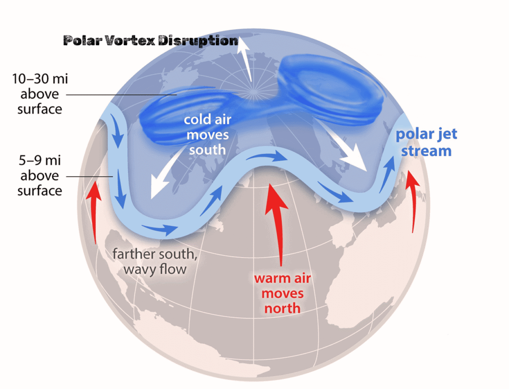
According to the latest weather forecast analysis, a “Sudden Stratospheric Warming” (SSW) event has destabilized the high-altitude winds that typically keep cold air locked at the North Pole. As a result, frigid Arctic air is forecast to “spill” southward, bringing prolonged cold outbreaks and potential snowstorms to North America, Canada, and parts of Europe.
The Forecast: What to Expect
Weather models indicate that the disruption will reach its peak impact in late January 2026, with effects lingering throughout February.
- United States: Forecasters warn of below-average temperatures sweeping across the Northern Plains, Midwest, and East Coast. The “unlocked” cold air increases the risk of travel-disrupting winter storms.
- Canada: Western and Central Canada are already acting as a reservoir for this building cold, which is set to expand southward.
- Europe: A similar pattern is expected across the Atlantic, where the weakened vortex will allow cold easterly winds to dominate, bringing harsh winter conditions to Northern and Central Europe.
Polar Vortex Explained: Why It Controls Winter Cold
To understand the severity of this forecast, it is essential to understand the mechanics of the Polar Vortex.
The Polar Vortex is a massive circulation of cold air that forms every winter over the Earth’s Polar Regions. It acts like a “spinning bowl” of wind, stretching from the surface up into the stratosphere, which traps the coldest Arctic air near the poles.
Meteorologists monitor the vortex in two main layers:
- Stratosphere (Upper Level): The “lid” on the bowl.
- Troposphere (Lower Level): The layer where our weather happens.
Why a Weak Polar Vortex Brings Extreme Cold
A strong Polar Vortex is trapping extremely cold air beneath it, keeping it from reaching farther areas. This is nature system that protects other regien from extreme weather condition. Global warning are now disrupting that natural shield exposing United States and Europe to extreme weather conditions.
This breakdown allows freezing Arctic air to spill southward, increasing the risk of:
- Below-average temperatures
- Snowfall and winter storms
- Extended cold outbreaks
This is the exact setup forecasters look for when predicting major winter weather events across the U.S., Canada, and Europe.
The Cause: Sudden Stratospheric Warming (SSW)
The current disruption is being driven by a phenomenon known as Sudden Stratospheric Warming (SSW).
- The Event: Temperatures in the stratosphere have risen rapidly, acting like a wrench in the gears of the polar circulation.
- The Result: This warming weakens and deforms the vortex, displacing the cold air from the pole. High-resolution forecast models show the vortex becoming increasingly unstable, a clear signal that significant cold air outbreaks will follow in the coming weeks.
Bottom Line
Forecasters are advising residents in the affected regions to prepare for a volatile end to the month. If the current models hold, Polar Vortex disruption could bring the coldest weather of the season to large parts of the United States and Canada, lasting well into February.